


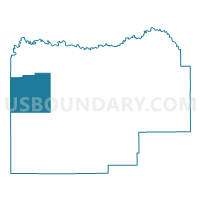
ATTERBERRY 10 Voting District, Menard County, Illinois
About
Outline

Summary
| Unique Area Identifier | 573572 |
| Name | ATTERBERRY 10 Voting District |
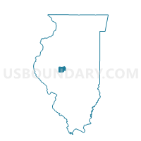
| County | Menard County |
| State | Illinois |
| Area (square miles) | 21.88 |
| Land Area (square miles) | 21.88 |
| Water Area (square miles) | 0.00 |
| % of Land Area | 100.00 |
| % of Water Area | 0.00 |
| Latitude of the Internal Point | 40.04343360 |
| Longtitude of the Internal Point | -89.94798090 |
Maps

Graphs
Select a template below for downloading or customizing gragh for ATTERBERRY 10 Voting District, Menard County, Illinois


Neighbors
Neighoring Voting District (by Name) Neighboring Voting District on the Map
- CHANDLERVILLE 18 Voting District, Cass County, IL
- NEWMANSVILLE 19 Voting District, Cass County, IL
- NORTH PETERSBURG 14 Voting District, Menard County, IL
- OAKFORD 9 Voting District, Menard County, IL
- SANDRIDGE 8 Voting District, Menard County, IL
- SOUTH PETERSBURG 15 Voting District, Menard County, IL
- TALLULA 11 Voting District, Menard County, IL
Top 10 Neighboring County Subdivision (by Population) Neighboring County Subdivision on the Map
- Petersburg South No. 15 precinct, Menard County, IL (1,259)
- Petersburg North No. 14 precinct, Menard County, IL (1,249)
- Tallula No. 11 precinct, Menard County, IL (653)
- Chandlerville township, Cass County, IL (515)
- Oakford No. 9 precinct, Menard County, IL (452)
- Atterberry No. 10 precinct, Menard County, IL (191)
- Sandridge No. 8 precinct, Menard County, IL (157)
- Newmansville township, Cass County, IL (50)
Top 10 Neighboring Unified School District (by Population) Neighboring Unified School District on the Map
- Porta Community Unit School District 202, IL (7,122)
- A-C Central Community Unit School District 262, IL (2,604)